Everett Neighborways
Creating a connected network of calm and comfortable streets for walking, biking, and rolling
Stay in the Loop
Sign up for project email updates here.
You will hear about ways to give feedback on plans, construction schedule updates, and get invites to neighborhood socials, pop-up events, and community paint day block parties! Come be a part of the changes to make your neighborhood more beautiful, bikeable, walkable, and connected. You’ll hear from us about once a quarter and can unsubscribe anytime. If you have any questions about the project, please email transportation@ci.everett.ma.us.

Quick Links
Project Resources
West and Wellington Neighborway Concept Plans
Everett Neighborways Network Interactive Map
Project Contacts
transportation@ci.everett.ma.us
Upcoming Events
Community Walk Audit and Neighborhood Social
Tues, August 19th, 6-8pm
Meet at Madeleine English Elementary School
(Rain Date: Thurs, Aug 21st)
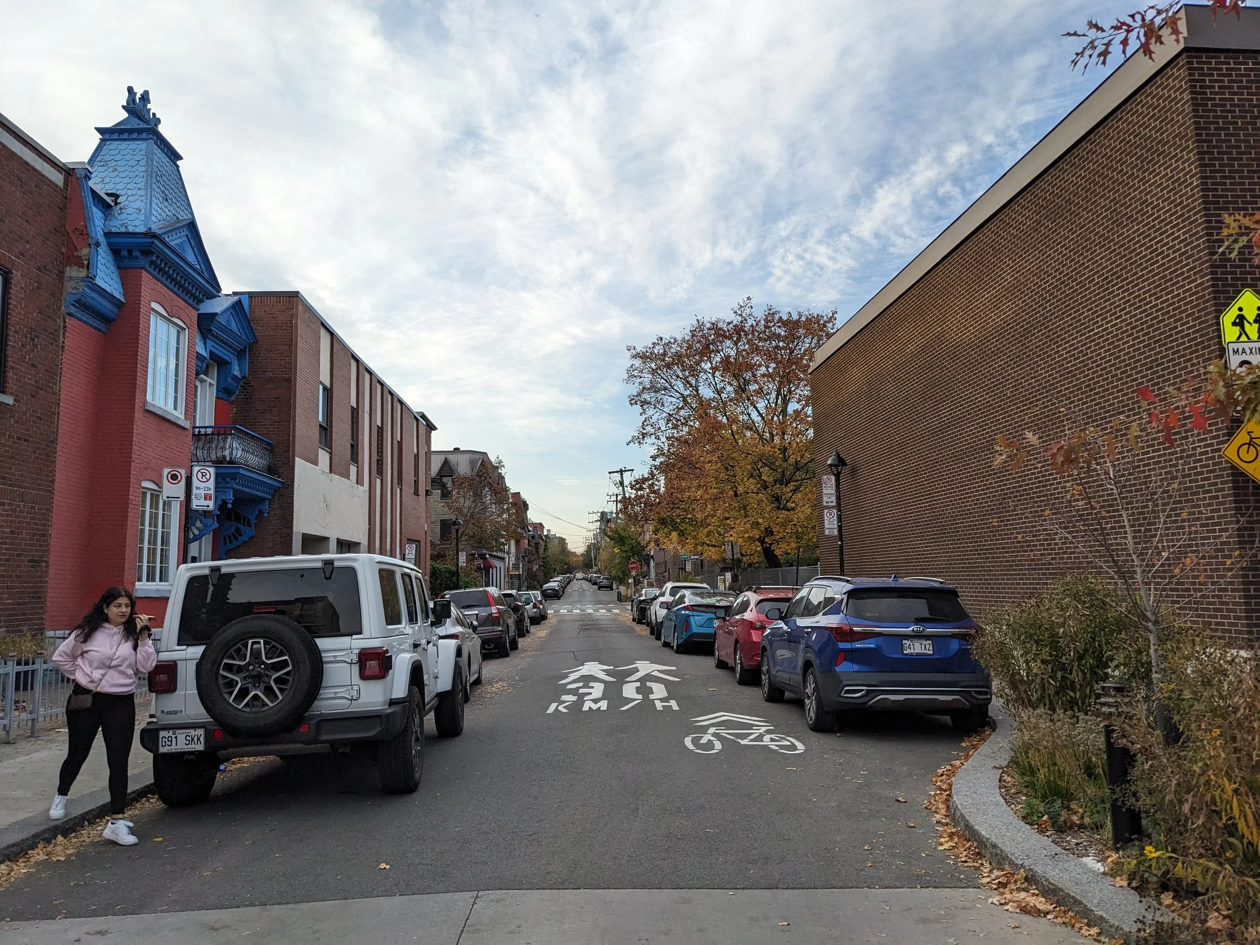
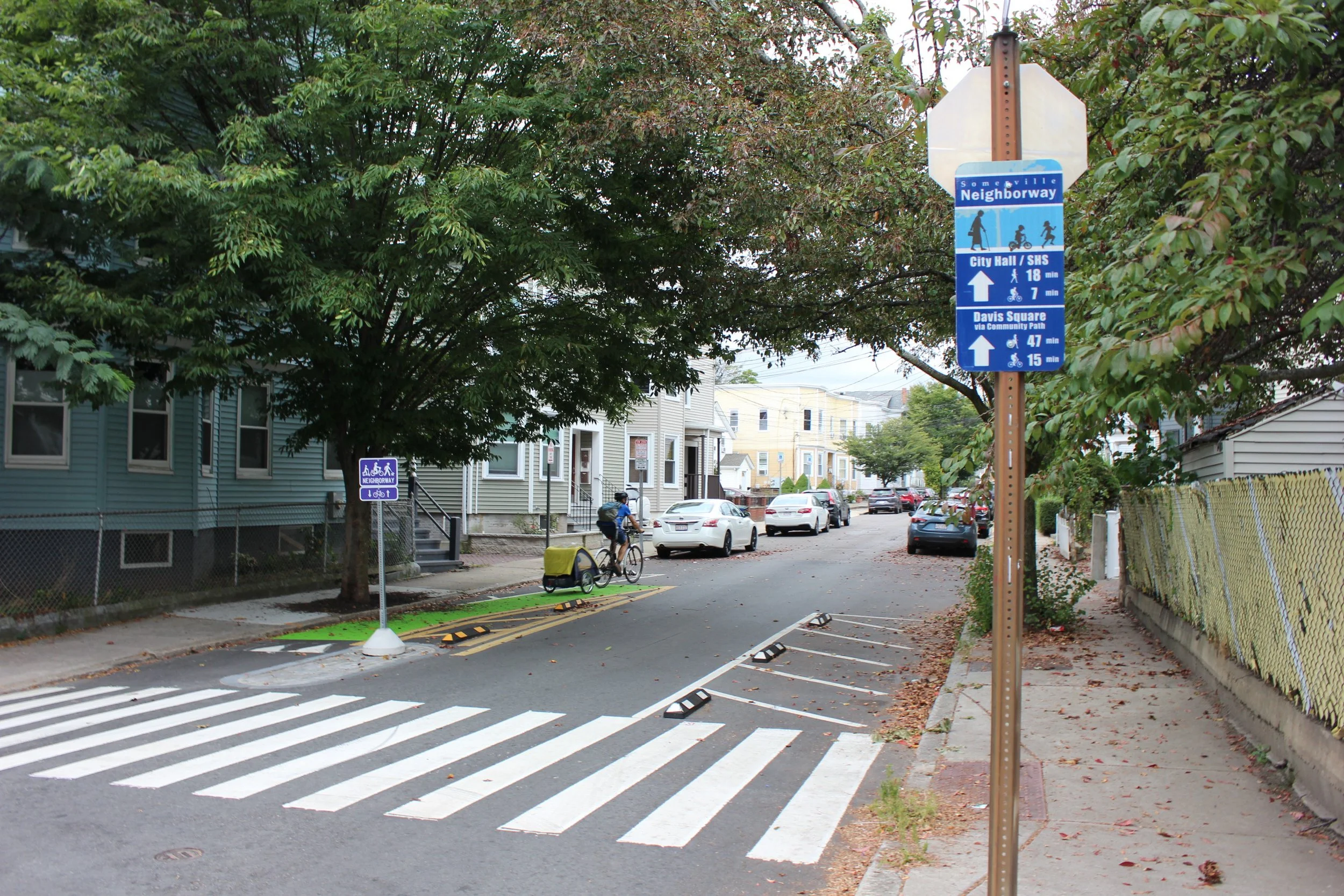
What’s a Neighborway?
Neighborways are:
Quiet, calm streets where it’s easy to meet your neighbors! Neighborways are the friendly, residential streets that run parallel to larger main streets and commercial districts.
Streets that prioritize the safety and comfort of people who are walking, biking, and rolling through neighborhoods – especially children and elders.
Sometimes known as “neighborhood greenways” or “bicycle boulevards” in other cities.
Designed to help people driving slow down with traffic calming tools like speed humps, curb extensions, street murals, plantings, etc.
Streets that provide a two-way connection for people walking, biking, and rolling even if the street is one-way for vehicular traffic.
Places that build community and facilitate social connections –– it’s the neighborly-way to meet your neighbors through socials, paint days, and block parties on your street!
Designed to be easily identifiable with branded signs, pavement markings, and sometimes public art.
Everett’s Neighborways will create a connected network of high comfort routes to schools, parks, the Northern Strand Trail, City squares, and other destinations.
Everett Neighborways Interactive Map
Click here to add your feedback to the map!
The Northern Strand Community Trail, also known as the Bike to the Sea Trail, is a 10-mile path running from Everett to Lynn providing a vital off-road trail connection and community asset for Everett and the Northern Mystic Region. The Northern Strand is also part of the East Coast Greenway route that runs from Maine to Florida!
The Northern Strand is the “spine” of Everett’s walking and biking infrastructure. Through the Neighborway program, the City will build safer, more comfortable, and beautiful connections to access and connect people to the Northern Strand and our city’s amazing destinations. Our goals are to establish an identifiable brand for Everett’s Neighborways, and implement placemaking and programming to increase walking, biking, and wheeling.
After talking with community members and City staff from 2022-2025, we’ve developed a DRAFT working map of potential Neighborway streets. Our first phase focuses on high priority connections to the Northern Strand Trail, with our second phase expanding throughout the City.

Share your Feedback!
We invite your comments, thoughts and feedback on these working draft routes. Where do you have trouble crossing the street? Have a favorite quiet, back-road bike or walking route to school, or the park that’s not on here? What do you think of these routes? Please share your feedback and comments on the map, or email us transportation@ci.everett.ma.us.
Everett Neighborway Projects
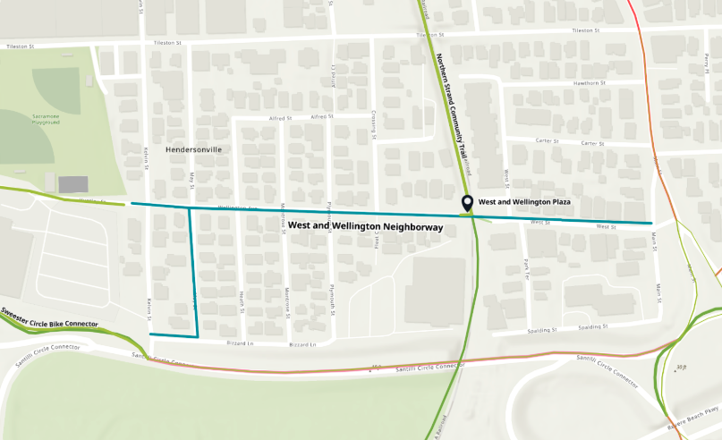
West and Wellington Neighborway Pilot
The City is working to implement Everett’s first Neighborway on West Street and Wellington Avenue, connecting The Village neighborhood to the Northern Strand! The West & Wellington Neighborway includes Bizarro Lane from Kelvin Street to May Street, Wellington Avenue from May Street to Park Terrace, and West Street from Park Terrace to Main Street. Proposed DRAFT design features along the West and Wellington Neighborway includes:
Wayfinding signage
Improved sidewalks
New crosswalks and ramps
Neighborway pavement markings;
Clear corners
Contraflow bike lane exit
Crossing Island
Placemaking features at West & Wellington plaza include new seating and tables, planters, shade structures, public art, bikeshare station, native plantings, and more!

Review the DRAFT design plans here.
Email your feedback to: transportation@ci.everett.ma.us.
Upcoming Events
Neighborhood Social + Walk Audit Summer Series
This summer, the City is hosting a series of walk audits and pop-up neighborhood socials to hear feedback from folks about how to make our street safer, more beautiful, and better connected. We’ll have fun, make friends, and share information on the DRAFT Everett Neighborway Network.
Tuesday, July 15, 6-8pm (Rain date Thursday, July 17th) Neighborhood Social @ West and Wellington Plaza on the Northern Strand . Free Snacks and drinks while supplies last!
Wednesday, July 24th 6-8pm (Rain date Thursday July 24th), Neighborhood Walk Audit and Social. 6pm meet in front of City Hall for a Walk Audit, and/or join us for a Neighborhood Social at the Swan Street Playground starting around 7pm.
Tuesday, August 19, 6-8pm (Rain date Thursday August 21st)
Neighborhood Walk Audit and Social. 6pm meet in front of Madeleine English Elementary School for a Community Walk Audit. 7pm Neighborhood Social at Bucknam Commons. RSVP HERE!
Join our mailing list to get the most up to date information and get special invites to neighborhood socials, block parties, and more!
